Black Cherry Trail
This information is a public record of the 1978 NRT application and may be out of date if it has not been updated by a trail manager --
check with the trail manager for updated details before visiting.
check with the trail manager for updated details before visiting.
Black Cherry Trail
USDA Forest Service
Backcountry Trail
- Length
1.4 miles
- Elevation Gain
--
- Route Type
out & back
- Length
1.4 miles - Elevation Gain
-- - Route Type
out & back
This trail is a 1.6-mile trail beginning and ending near the lower campground loop.
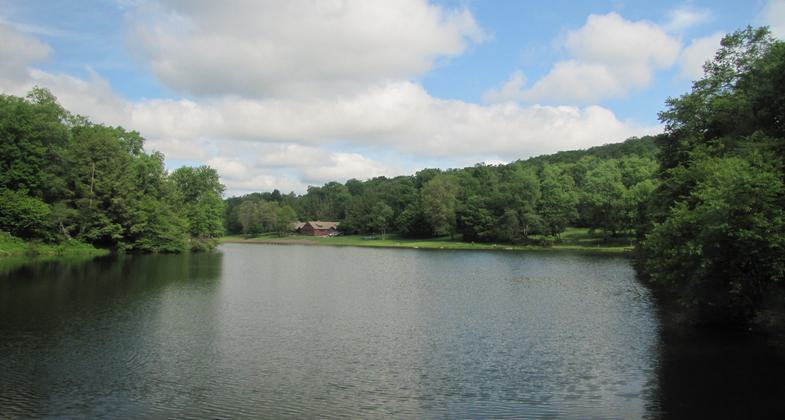
Location: In the Allegheny NF at Twin Lakes Campground, 4 mi. SE of Kane.
- States: Pennsylvania
- Counties: Elk
This trail is a 1.6-mile trail beginning and ending near the lower campground loop. The two loops, one 1-mile loop, and one .4-mile loop circle the campground. The Black Cherry Trail also makes up the eastern end of the Twin Lakes Trail. The trail will take you through a valley with a small stream, that you will cross at one point. The Twin Lakes Trail connects to both the Mill Creek Trail and Brush Hollow Trail systems.
Accessibility Information
No text provided.
Allowed Uses:
Hiking/WalkingPublic Contact
Allegheny National ForestP.O. Box 847
Marienville, PA 16239
(814) 927-6622
www.fs.fed.us/r9/allegheny
Contact the trail manager for current maps and visiting details.
More Details
- Elevation (low): 1760
- Elevation (high): 1920
- Elevation (cumulative): --
- Part of a Trail System? No
- Surface (primary): Soil
- Surfaces (additional): --
- Tread Width (average): 24"
- Tread Width (minimum): --
- Running length (minimum): --
- Tread Grade (average, percent): --
- Tread Grade (maximum):
- Running length (maximum): --
- Cross-slope (average, percent): --
- Cross-slope (maximum): --
- Running length (maximum): --
- Certified as an NRT
Dec 17, 1978