Bizz Johnson Trail
check with the trail manager for updated details before visiting.
Bizz Johnson Trail
USDA Forest Service
Rail Trail
- Length
25.5 miles
- Elevation Gain
--
- Route Type
out & back
(1 review)
- Length
25.5 miles - Elevation Gain
-- - Route Type
out & back
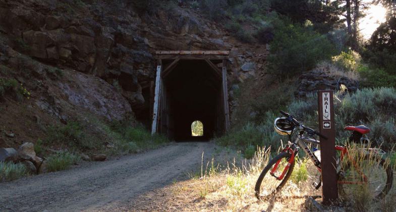
Tunnel on the Bizz Johnson Trail, near Susanville, CA; photo by Dana Buzzelli, International Youth Leadership Foundation.

Photo by Dana Buzzelli.

Looking over the Susan River from the trail. Photo by Dana Buzzelli.
Location: Connects Susanville W and S to Westwood and Mountain Meadows Reservoir.
- States: California
- Counties: Lassen
Following the old Fernley and Lassen branch line of the Southern Pacific Railroad, the trail winds 25.4 miles from the Susanville Railroad Depot to the Mason Station trailhead north of Westwood.
Most of the trail runs through the rugged Susan River Canyon with its beautiful views of the surrounding mountains and reminders of the railroad logging days of the past. Horseback riders, hikers, joggers, and mountain bicyclists use the trail. In snowy winter months, cross-country skiers and snowmobilers use the upper reaches.
Accessibility Information
No text provided.
Reviews
John Bighorn
I can see why its in the Rail Trail Hall of Fame
My partner and I rode the entire 25.5 miles from Mason Station back to Susanville last fall. We were able to catch a ride from the local bus service from Susanville up to a gas station just outside of the charming town of Westwood. Once dropped off we were a little confused as where to go, then we saw the sign stating the"trailhead" was 3 miles down the road (A-21). We were not prepared for a road section but the route was flat and we only saw 1 car. There is a nice shaded trailhead at Mason Station with restrooms. The trail starts of with a slight incline for a few miles, this section was a little lose too, a skinny tire road-bike would not be recommended for this section but our hybrid bikes were fine. Once the trail starts descending the tread improves and you are quickly following alongside the Susan River. The lower 9 miles was by far our favorite (Devils Corral to Susanville). The ride is an easy slight decline winding through the beautiful river canon. Rock outcrops, tunnels, wildlife, amazing fall colors, swimming holes and few people! What a wonderful trail. The bus shuttle was nice too, after a day of riding we ended up right back at our car!
Allowed Uses:
Bicycling Equestrian Hiking/Walking Snow, cross-country skiingOther Activities
- Snow, snow play general
Public Contact
Tammy Benner477-050 Eagle Lake Rd
Susanville, CA 96130
[email protected] • (530) 257-1488
Contact the trail manager for current maps and visiting details.
More Details
- Elevation (low): 4300
- Elevation (high): 5000
- Elevation (cumulative): --
- Part of a Trail System? No
- Surface (primary): Rock, crushed
- Surfaces (additional): Rock, crushed
- Tread Width (average): 96"
- Tread Width (minimum): --
- Running length (minimum): --
- Tread Grade (average, percent): 2
- Tread Grade (maximum): 4
- Running length (maximum): --
- Cross-slope (average, percent): --
- Cross-slope (maximum): --
- Running length (maximum): --
- Certified as an NRT
Sep 19, 1992