Big Trees
check with the trail manager for updated details before visiting.
Big Trees
USDA Forest Service
- Length
1.4 miles
- Elevation Gain
--
- Route Type
out & back
- Length
1.4 miles - Elevation Gain
-- - Route Type
out & back
The Big Trees Nature Trail is a 1/2-mile loop through the northern-most grove of giant sequoias.
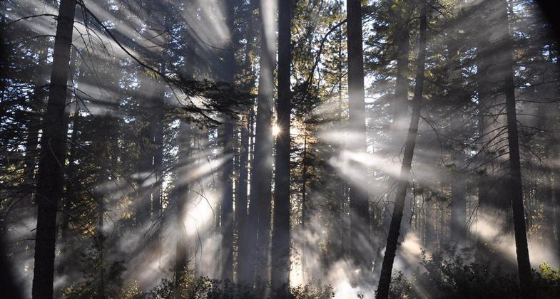
Smoke filters thru trees during a prescribed burn. Photo by USFS.

Placer Big Trees giant sequoia grove located outside of Foresthill, CA, on the Tahoe NF's American River Ranger District. Photo by USFS/Danielle Kelly.
Location: Tahoe National Forest, In Tahoe National Forest, S of I-80, E of Georgetown off Mosquito Ridge Rd.
- States: California
Placer Big Trees Grove is the most northerly stand of naturally occurring Giant Sequoias. The grove is located 23 miles east of Foresthill overlooking the Middle Fork American River. The area has been designated as a Botanical Special Interest Area by the Forest Service. The trees have been a popular tourist attraction since the 1800s and each bears the name of a prominent individual from presidents to generals to local politicians.
The tallest tree in the grove is the Joffre tree, standing over 250 feet tall. Marshal Joseph Jacques Cesaire Joffre was a French general during World War I. The largest tree when measured by volume is the Pershing tree, standing 225 feet tall and 12 feet in diameter at breast height.
Walking the half-mile-long trail at a leisurely pace takes about 25 minutes. most of the trees are named after distinguished people. On the larger trees, you will see damage to the bark caused by bears a century ago. A few of the giants have fallen. Those standing are estimated to be 500 to 700 years old, mere teenagers in the lives of Giant Sequoias.
Accessibility Information
No text provided.
Allowed Uses:
Hiking/WalkingPublic Contact
Tahoe National Forest631 Coyote St.
Nevada City, CA 95959
(530) 265-4531
Contact the trail manager for current maps and visiting details.
More Details
- Elevation (low): --
- Elevation (high): --
- Elevation (cumulative): --
- Part of a Trail System? No
- Surface (primary): --
- Surfaces (additional): --
- Tread Width (average): 0"
- Tread Width (minimum): --
- Running length (minimum): --
- Tread Grade (average, percent): --
- Tread Grade (maximum):
- Running length (maximum): --
- Cross-slope (average, percent): --
- Cross-slope (maximum): --
- Running length (maximum): --
- Certified as an NRT
Dec 12, 1979