Bear Valley Lakes Trail
This information is a public record of the 1979 NRT application and may be out of date if it has not been updated by a trail manager --
check with the trail manager for updated details before visiting.
check with the trail manager for updated details before visiting.
Bear Valley Lakes Trail
USDA Forest Service
Backcountry Trail
- Length
6 miles
- Elevation Gain
--
- Route Type
out & back
- Length
6 miles - Elevation Gain
-- - Route Type
out & back
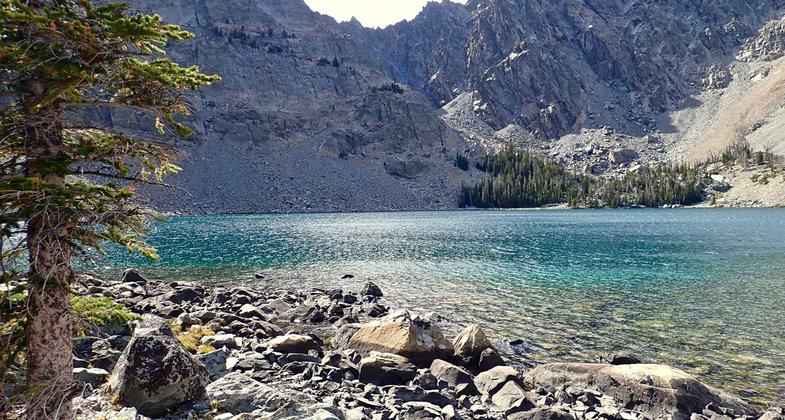
Bear Valley Lake as seen from near the end of the trail at 9135' elevation in the core of the Lemhi Mountain Range. Photo by David Lingle.

Bear Valley Creek can be seen here below the trail. Photo by David Lingle.

Near the Lower Trailhead, the trail runs through open sage meadows. Photo by David Lingle.

Looking down the trail about halfway up to Bear Valley Lake. Photo by David Lingle.

The bridge across Bear Valley Creek near the Upper Trailhead. Other big water crossings also have bridges going up to the lake. Photo by David Lingle.

The beginning of the Bear Valley Lake Trail. Photo by David Lingle.

Bear Valley Pack and Saddle Campground and Trailhead has several campsites, water and feed troughs. Photo by David Lingle.

Sign pointing the way to the Lower Trailhead open to non-motorized use. Photo by David Lingle.

New water crossing (on the nearby Bear Valley High Trail #6178). Photo by Marc Landblom.

Old water crossing (on the nearby Bear Valley High Trail #6178). Photo by Marc Landblom.

Location: Location Salmon-Challis National Forest on Bear Valley Creek Road #009, 40 miles from Salmon.
- States: Idaho
- Counties: Lemhi
There are two trailheads. The lower being non-motorized at the Bear Valley Pack and Saddle Trailhead and Campground. .8 miles further is the Upper Bear Valley Trailhead and Campground. The trail climbs gradually through sage meadows and open forest for the first two miles. Then the forest thickens and the trail steepens with some rough, rocky sections-fine for hiking but it can be tough for other uses. Nearing Bear Valley Lake, the trail levels out in sub-alpine meadows. There are junctions along the way to Buck Lakes and Upper Bear Valley Lakes.
Accessibility Information
No text provided.
Allowed Uses:
Bicycling Dogs, on leash EquestrianOther Activities
- Camping
- Fishing
Public Contact
Salmon-Challis National Forest1206 S. Challis St.
Salmon, ID 83467
(208) 756-5100
Contact the trail manager for current maps and visiting details.
More Details
- Elevation (low): 6700
- Elevation (high): 9150
- Elevation (cumulative): --
- Part of a Trail System? No
- Surface (primary): Soil
- Surfaces (additional): Soil
- Tread Width (average): 18"
- Tread Width (minimum): --
- Running length (minimum): --
- Tread Grade (average, percent): 10
- Tread Grade (maximum): 20
- Running length (maximum): --
- Cross-slope (average, percent): --
- Cross-slope (maximum): --
- Running length (maximum): --
- Certified as an NRT
Aug 16, 1979