Bear Butte Summit Trail
check with the trail manager for updated details before visiting.
Bear Butte Summit Trail
State
Backcountry Trail
- Length
3.5 miles
- Elevation Gain
--
- Route Type
out & back
- Length
3.5 miles - Elevation Gain
-- - Route Type
out & back
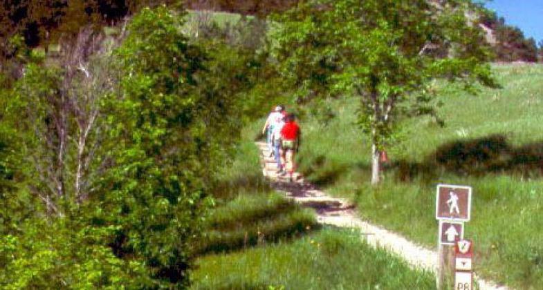
n Bear Butte State Park, western South Dakota, close to Sturgis; photo by Dana Garry, South Dakota Game Fish and Parks Dept.
Location: In Bear Butte SP, 10 mi. NE of Sturgis on SD 79.
- States: South Dakota
- Counties: Meade
Mato Paha, or bear mountain, is the Lakota Indian name for this outstanding geological formation. In actuality, it is the remains of a volcano that did not erupt. Geologists call it a laccolith. Legend says that Bear Butte received its name because from a distance it looks like a sleeping bear.
Nearby campsites have been dated to be more than 4,000 years old. Through the centuries, thousands of people have come here to be inspired. American Indian people from over 15 tribes still come here to fast, pray, seek visions, present offerings to their sacred spirits, and undergo personal sacrifice. Please show your respect to the people who are here for these purposes.
Visits by notable American Indian leaders such as Red Cloud, Crazy Horse, Man Afraid, Little Wolf, and Sitting Bull are recorded in Bear Butte's history. The earliest visits by Caucasian people began with the visit of the Verendrye Expedition in 1742. A succession of mountain men and scientists followed. In 1874, George Armstrong Custer led an expedition of 1,000 men to explore the Black Hills. Although his command camped a few miles south of the butte, several men accompanied Custer to the summit of Bear Butte. After Custer and his men verified the rumors of gold in the Black Hills, Bear Butte served as a landmark for prospectors and settlers who came seeking wealth.
Accessibility Information
No text provided.
Allowed Uses:
Hiking/WalkingPublic Contact
South Dakota Dept. of Game, Fish & ParksP.O. Box 688
Sturgis, SD 57785
(605) 347-5240
Contact the trail manager for current maps and visiting details.
More Details
- Elevation (low): --
- Elevation (high): --
- Elevation (cumulative): --
- Part of a Trail System? No
- Surface (primary): Soil
- Surfaces (additional): --
- Tread Width (average): 0"
- Tread Width (minimum): --
- Running length (minimum): --
- Tread Grade (average, percent): --
- Tread Grade (maximum):
- Running length (maximum): --
- Cross-slope (average, percent): --
- Cross-slope (maximum): --
- Running length (maximum): --
- Certified as an NRT
Jun 1, 1971