Bayou Teche Paddle Trail
check with the trail manager for updated details before visiting.
Bayou Teche Paddle Trail
Nonprofit
National Water Trail
- Length
135 miles
- Elevation Gain
--
- Route Type
out & back
(2 reviews)
- Length
135 miles - Elevation Gain
-- - Route Type
out & back
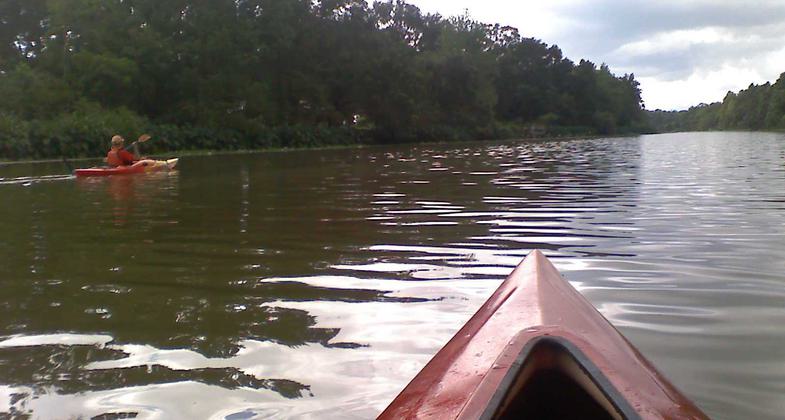
Bayou Teche Paddle Trail is a 135-mile long paddle trail through four parishes and 13 towns along the most historically and culturally significant bayou in Louisiana. Named by the Chitimacha Tribe of Louisiana.


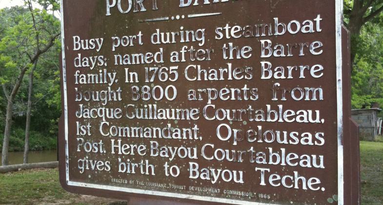
Location: St. Landry, St. Martin, Iberia and St. Mary Parishes. BTPT begins in Port Barre, LA at Bayou Courtableau and runs 135 to Berwick, LA.
- States: Louisiana
- Counties: Iberia, St. Landry, St. Martin, St. Mary
- Cities/Townships: Port Barre, Arnaudville, Cecilia, Breaux Bridge, Parks, St. Martinville, Loreauville, New Iberia, Baldwin, Franklin
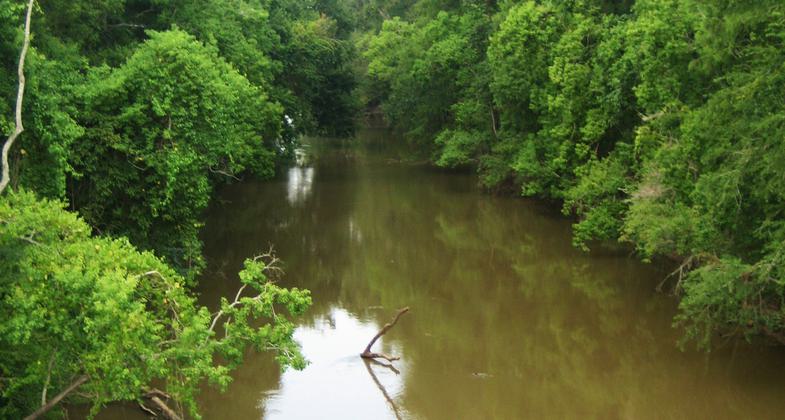
The Bayou Teche watershed is a small watershed within the Mississippi River Basin, draining approximately 58,500 acres of natural, agricultural, and urban lands into Vermilion Bay. Bayou Teche runs 136 miles from Port Barre to Berwick through St. Landry, St. Martin, Iberia, and St. Mary parishes and is easily accessed from several state highways and Interstate 10. The water trail flows through the towns of Port Barre, Arnaudville, Breaux Bridge, Parks, St. Martinville, Loureauville, New Iberia, Jeanerette, Charenton (Chitimacha Tribe of Louisiana lands), Baldwin, Franklin, Patterson, Berwick, and small villages in between. Each town has a standard motorboat launch and many are being equipped with floating docks specifically designed for kayaks and canoes. Primitive camping is available.
Accessibility Information
No text provided.
Reviews
Jody Broussard
Right in our backyard
As a native of South Louisiana, spent much of my youth in the brown waters of the Teche. Paddled from Arneaudville to Breaux Bridge (15 miles) yesterday afternoon and was reminded just how lucky we are to have this scenic waterway in our backyard. The other reviewer has an excellent point, however, and there should be more camping opportunities along the route. I'm still giving it 5 stars because it's a work in progress and having Louisiana represented is worth it.
Jake Williams
Underutilized and Beautiful.
I have lived on the Teche my entire life and have a great appreciation for its beauty and cultural significance to South Louisiana. I enjoy Bayou Teche literally everyday of my life through either fishing, paddling, or watching it flow by. I recently attempted to paddle the roughly 135 mile long Bayou Teche from it's source at Bayou Courtableau to it's mouth at the Atchafalaya River (loved every minute of it) and was extremely disappointed when I had to end my trip about 72 miles into it at New Iberia because there are simply no places to camp on the Bayou. I know that the info above says that primitive camping is available, but that is not really accurate. The only place where you can legally camp primitively along the bayou that I was able to locate after contacting each Parish and Town governments along the Bayou was in the Village of Parks. They have a very nice/convenient RV park on the bayou that allows tent camping for $10/night. It is wild that Bayou Teche is the only National Paddle Trail in the state and one of only twenty-two nationwide but is super unaccommodating to paddlers looking to trip the entire bayou. I will be going back to finish the trip I started in a few months and I guess I will just trespass with the hopes of not getting caught camping at night. Many, if not all, of the towns along the Teche have bayou-front parks and it seems that the camping issue could/would be an easy fix, but until then I really think that the state is fumbling away a gift that could bring positive tourism dollars to the area each year and the nation is missing out on an awesome time on a beautiful bayou.
Allowed Uses:
Boating, motorized Boating, human-poweredOther Activities
- Camping
- Fishing
- Heritage and history
- Wildlife viewing / observation
More Details
- Elevation (low): --
- Elevation (high): --
- Elevation (cumulative): --
- Part of a Trail System? No
- National Designations: Atchafalaya National Heritage Area
- State Designations: Proposed Louisiana Scenic and Historic River
- Surface (primary): --
- Surfaces (additional): --
- Tread Width (average): 0"
- Tread Width (minimum): 0
- Running length (minimum): --
- Tread Grade (average, percent): --
- Tread Grade (maximum):
- Running length (maximum): --
- Cross-slope (average, percent): 0
- Cross-slope (maximum): --
- Running length (maximum): --
- Certified as an NRT
Jan 4, 2015