Backbone Trail
check with the trail manager for updated details before visiting.
Backbone Trail
National Park Service
Backcountry Trail
- Length
67 miles
- Elevation Gain
--
- Route Type
out & back
(1 review)
- Length
67 miles - Elevation Gain
-- - Route Type
out & back
The Backbone Trail is a 67-mile trail system following the east-west trending crest and canyons of the Santa Monica Mountains. The trail connects three California State Parks and traverses National Park Service-owned Zuma/Trancas Canyons and Circle X Ranch, all within Santa Monica Mountains National Recreation Area.

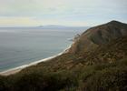
Ocean view from Backbone Trail, Ray Miller Trail in Point Mugu State Park. Photo by National Park Service

Sunset ride near the Pacific Ocean. Photo by Oliver Cudrigh.

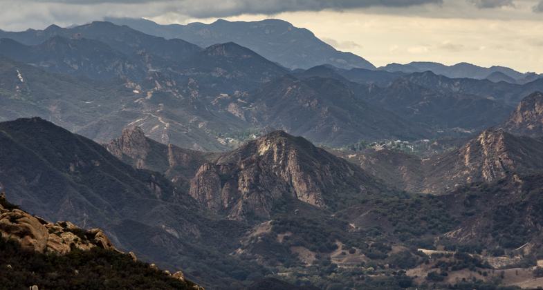
A view on the Stunt road to Piuma Road Section of the Backbone Trail. Photo by Carl L Burdick (@carlburdick).
Location: The Backbone Trail runs along the east-west ridgelines and canyons of the Santa Monica Mountains, from Will Rogers State Historic Park in the city of Los Angeles to Point Mugu State Park in Ventura County.
- States: California
- Counties: Los Angeles, Ventura
- Cities/Townships: City of Los Angeles, Unincorporated Los Angeles County, Unincorporated Ventura County
The Backbone Trail is one of the most attractive long-distance trails in southern California, amazing for its urban-wildland contrast. The Backbone Trail is situated adjacent to one of the most densely populated and ethnically diverse metropolitan areas in the United States. Approximately 17 million Californians live within an hour's drive of the trail. Yet, visitors can take in a great diversity of scenery, with several trail experiences to choose from: narrow footpaths close to nature, multi-use trails that are not steep and are easy on the heart and knees, and fire roads. The trail is enjoyed by a broad range of visitors, from those seeking a one-day outing within their comfort level in an outdoor setting to those training for a backpacking trip.
The trail stretches 67 miles from Will Rogers State Historic Park in Los Angeles to Point Mugu State Park in Ventura County where the mountains meet the Oxnard Plain. It generally follows the crest of the Santa Monica Mountains, with elevations from near sea level to just over 3,000 feet at Sandstone Peak, the highest point in the mountains.
Early visions from 50 years ago called for a "Ridge Trail," aligned from Griffith Park in the City of Los Angeles to Point Mugu State Park. That idea, however, never went forward owing to difficulty weaving a trail among development in the Hollywood Hills and along Mulholland Drive. In the 1970s, with the establishment of State Parks in the mountains, the notion began to crystallize and a route, now widely referred to as the "Backbone Trail," was proposed to start at Will Rogers State Historic Park and Topanga State Park in the east, pass through Malibu Creek State Park in the center, and terminate in Point Mugu State Park in the west.
During the 1980s, inspired community members partnered with California State Parks, the Santa Monica Mountains Conservancy, the Mountains Recreation and Conservation Authority, and the National Park Service. By 1993, 31 miles of new trail had been constructed by one remarkable individual and youth training organizations including California and Los Angeles Conservation Corps. With existing fire roads, 51 miles were then open to the public. The remaining 16 miles across a six-mile stretch of private land took another 23 years to complete.
Over 180 transactions to piece together land and public access rights were needed, with a story to tell about each acquisition. Just three privately owned gaps tenaciously lingered until the impasse was broken by a unified vision to complete the trail during the National Park Service's 2016 Centennial Celebration. The remaining gaps were closed just in time for the Secretary's announcement of the new National Recreation Trails on National Trails Day, June 4, 2016.
Trail users today can experience the beauty and rich biodiversity of the coastal Mediterranean ecosystem, found in only five regions in the world. The trail crosses roads at several points where there are trailheads, making segment outings of six to ten miles readily feasible. Additionally, most of the other 450 miles of trails within the recreation area connect in one fashion or another to the Backbone Trail. The whole trail is open to hiking and horseback riding. Portions of the trail are open to mountain biking. Dog walking is allowed on parts of the trail owned by the National Park Service. The trail is still a work in progress when it comes to camping, with only two camps along the trail, and three more a moderate distance from the trail. Currently, the best way to enjoy the trail is in a series of day trips.
Accessibility Information
No text provided.
Reviews
Dorothy Sadd
Latigo Canyon Rd to Castro Crest & Upper Solstice
Lovely hike but BEWARE of your GPS
1. Google and Apple Maps will suggest you take Castro Motorway. This sounds like a real road but it is actually private property. And it is quite a distance from any other trailhead
2. The Latigo canyon trailheads going NorthWest or Southeast have very small signs and a small sandy parking area off to the right on Latigo Canyon Rd BEFORE Castro Motorway
3. The Backbone trail on both sides of Latigo Canyon was entirely burned during the 2018 Woolsey Fire BUT there is a lot of new growth (as of Sept 2019). You can see the charred trees everywhere but the trail is very much in tact.
4. We did not see a single other hiker - Sunday 12-3pm so advisable to not go alone...its is rocky in some places so if you turned an ankle or hurt a knee, you'd be really out in the middle of nowhere alone (aka dangerous)
5. Easier entrance than Latigo canyon Rd seems to be coming up from Pepperdine area to Upper Solstice
6. If I were to hike Latigo canyon again, I would approach from Calabasa
7 The views are stunning - We could see the Channel Islands...and by the end of the hike could see the marine layer engulfing the entire pacific
Bring Water - and have a ball
p.s. Private property along Castro Motorway should be marked and closed off on all GPS. It was quite strange that Google had not updated this at all...in fact sent us on the private road. Very Strange.
Allowed Uses:
Bicycling Dogs, on leash Equestrian Hiking/WalkingOther Activities
- Camping
- Wildlife viewing / observation
Public Contact
Joseph EdmistonMountains Recreation and Conservation Authority
5750 Ramirez Canyon Rd.
Malibu, CA 90265
[email protected] • (323) 221-9944
Contact the trail manager for current maps and visiting details.
More Details
- Elevation (low): 25
- Elevation (high): 3007
- Elevation (cumulative): --
- Part of a Trail System? No
- Surface (primary): Soil
- Surfaces (additional): --
- Tread Width (average): 53"
- Tread Width (minimum): 24
- Running length (minimum): --
- Tread Grade (average, percent): 8
- Tread Grade (maximum): 13
- Running length (maximum): --
- Cross-slope (average, percent): 6
- Cross-slope (maximum): --
- Running length (maximum): --
- Certified as an NRT
Jun 1, 2016