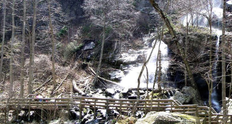
Apple Orchard Falls
check with the trail manager for updated details before visiting.
Apple Orchard Falls
USDA Forest Service
Backcountry Trail
- Length
3.5 miles
- Elevation Gain
--
- Route Type
out & back
- Length
3.5 miles - Elevation Gain
-- - Route Type
out & back
An excellent hiking trail for members of the whole family, young and old alike. This trail is easy to moderate in most places, but some stretches are difficult.
Location: Connects to AT and Sunset Field overlook on the Blue Ridge Parkway. George Washington & Jefferson National Forests
- States: Virginia
For the most part, these are excellent hiking trails for members of the whole family, young and old alike. These trails are easy to moderate in most places, but some stretches are difficult. Read the descriptions below to plan your hike.
The easiest route is from the bottom at the end of FS 59 along North Creek to the falls, although the last half-mile gets rocky and steeper. From the falls to the Blue Ridge Parkway, the trail is steep. You will see rhododendron, turtle head, mountain fetterbush, trillium, bleeding hearts, and showy orchis, as well as many other plants. North Creek is home to a rare species of aquatic lichen, the waterfan.
Safety First: There are several bridge crossings on these trails; some have several steps at each end. Beware of slippery rocks and please stay on the trail. There is a safe viewing area at the falls. Do not attempt to climb the rocks around the falls as they are wet, slippery, and very dangerous. Always carry a snack, water, and a light raincoat, and wear (comfortable) hiking boots, when hiking.
Accessibility Information
No text provided.
Allowed Uses:
Hiking/WalkingPublic Contact
David BenavitchJefferson National Forest
Glen wood Ranger District
National Bridge Station, VA 24579
(540) 265-5100?
Contact the trail manager for current maps and visiting details.
More Details
- Elevation (low): --
- Elevation (high): --
- Elevation (cumulative): --
- Part of a Trail System? No
- Surface (primary): --
- Surfaces (additional): --
- Tread Width (average): 24"
- Tread Width (minimum): --
- Running length (minimum): --
- Tread Grade (average, percent): --
- Tread Grade (maximum):
- Running length (maximum): --
- Cross-slope (average, percent): --
- Cross-slope (maximum): --
- Running length (maximum): --
- Certified as an NRT
Sep 13, 1987