Apalachicola River Blueway
check with the trail manager for updated details before visiting.
Apalachicola River Blueway
Nonprofit
Water Trail (other)
- Length
106 miles
- Elevation Gain
--
- Route Type
out & back
- Length
106 miles - Elevation Gain
-- - Route Type
out & back
The majestic Apalachicola River flows through one of the nation's richest hotspots of biodiversity and is bordered by large tracts of pristine, undeveloped land, home to many threatened and rare species of plants and animals. The river meanders through the heart of"Old Florida," a vibrant tapestry of wild landscapes and vanishing cultures" a rare gem in the Florida Panhandle.

Apalachicola Blueway. Photo by Earl Morrough

Winner 2022 NRT Photo Contest, Youth and Volunteers. Photo by Doug Alderson.

Side Slough along Apalachicola River Blueway. Photo by Doug Alderson.

Estifinulga moonrise. Photo by Doug Alderson.
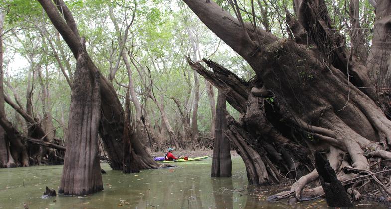
Huge Cypress knees. Photo by Doug Alderson.

Kayaker by Alum Bluff on a foggy morning. Photo by Doug Alderson.

Sunset near Alum Bluff. Photo by Doug Alderson.

Photo by Doug Alderson.

Photo by Doug Alderson.
Location: The Apalachicola River Blueway begins below the dam in the town of Chattahoochee and flows 107 miles to the Gulf of Mexico.
- States: Florida
- Counties: Jackson, Calhoun, Franklin, Gadsden, Liberty, Gulf
- Cities/Townships: Chattahoochee, Bristol, Blountstown, Wewahitchka, Apalachicola
The Apalachicola River is undammed and largely wild, flowing through the heart of one of the nation's six hot spots of biodiversity. Large tracts of public and protected lands feature high bluffs, abundant wildlife, and rare animals and plants making this river among the most unique in Florida.
The watershed is a primary spawning and nursery habitat for fish and other aquatics and is a critical migratory bird route. The river basin's varied habitats, from rare steep head ravines with the only native Torreya taxifolia, found anywhere to bottomland hardwood forests, give it the highest species density of amphibians and reptiles on the continent, north of Mexico. The natural beauty of this undeveloped region is further enhanced by the small riverside communities serving up "Old Florida" hospitality flavored with rich history and colorful culture.
The historic Apalachicola River has always been an important waterway providing transport and enhancing commerce since the first Floridians arrived 12-14,000 years ago. During the 1830s and 1840s large numbers of steamboats shipped cotton from inland plantations to Apalachicola for export until the blockade of Apalachicola Bay by Union forces during the Civil War effectively stopped steamboat travel. After the war, lumber became the dominant cargo. Sawmills sprang up along the river, and millions of board feet of longleaf pine and cypress passed through the port of Apalachicola. Stumps of huge trees that were cut during logging operations can still be seen along the river banks. The famous local oyster industry began in the later part of the 19th century and until recently the productive bay was generating 90% of the state's commercial oyster harvest.
The Apalachicola River Blueway website provides information about access points, points of interest, and other amenities found along the river that can contribute to a successful waterway experience for paddlers and boaters. The river can have a fast current and high winds may be encountered near the Gulf of Mexico, so it is not recommended for beginning paddlers. Mile markers along the shores, decreasing from 106 at the dam in Chattahoochee to 0 in Apalachicola, provide helpful navigational guides. Barge traffic and dredging are a thing of the past, but buoys and large sand mounds are still visible. During low to moderate water levels, these numerous sandbars offer ideal rest stops and primitive campsites until the sandbars disappear on the lower portion of the river as it widens into an increasingly swampy floodplain.
Numerous side streams are worthy of exploration. The River Styx, Kennedy Creek, Owl, and Devon Creeks in the Apalachicola National Forest meander beneath a shady canopy of cypress and tupelo trees. Another recommended side trip is to explore the Chipola River Dead Lakes area. This is a wide swampy area of stunning primeval beauty with both dead and living cypress trees originally formed by the creation of a naturally occurring levee.
While there is good fishing along the entire Apalachicola River, the best areas are the upper river, where the largemouth bass, catfish, striped bass, and bream catches are excellent. The lower river estuary, which is influenced by Apalachicola Bay and the Gulf of Mexico, supports a substantial seafood harvest, including oysters, shrimp, and numerous tasty saltwater fish species.
The Apalachicola River basin is well-known for the production of distinctive tupelo honey and beehives on platforms and floats may be glimpsed along the shady banks of the river. If paddling down the quiet creeks and bayous lined with blooming tupelo, titi, and black gum in mid-April or May, one may hear a loud steady hum of honey bees. The tasty tupelo honey produced within the Apalachicola watershed is the only place where this honey is produced commercially and provides a historic and important component of the local economy.
The Apalachicola River Blueway connects with another National Recreation Trail, the Apalachicola River Paddling Trail System, in the lower estuary portion of the river. This 100-mile matrix of scenic waterways was developed by the Florida Fish and Wildlife Conservation Commission and designated a National Recreation Trail in 2008.
Exploring the remote wetland creeks or expansive vistas of the open bays allows the observant, quiet visitor a wonderful opportunity for spotting a variety of birds and wildlife including alligators, bald eagles, and osprey. A lucky few may catch a glimpse of a Florida black bear. Wildlife viewing is excellent throughout the year and masses of splendid wildflowers bloom in the spring and fall. This area includes several sites on the Great Florida Birding Trail and is accessible from the Big Bend Scenic Byway
Make plans to explore the majestic Apalachicola River Blueway as it meanders through the heart of "Old Florida." Discover a vibrant tapestry of wild landscapes and vanishing cultures" a rare gem in the bustling state of Florida.
Accessibility Information
No text provided.
Allowed Uses:
Boating, motorized Boating, human-poweredOther Activities
- Camping
- Fishing
- Heritage and history
- Hunting
- Wildlife viewing / observation
Public Contact
Dan TonsmeireApalachicola Riverkeepers
Box 8
Apalachicola, FL 32320
[email protected] • (850) 653-8936
More Details
- Elevation (low): --
- Elevation (high): --
- Elevation (cumulative): --
- Part of a Trail System? No
- State Designations: State Paddling Trail
- Surface (primary): Water, slow moving
- Surfaces (additional): --
- Tread Width (average): 0"
- Tread Width (minimum): 0
- Running length (minimum): --
- Tread Grade (average, percent): --
- Tread Grade (maximum):
- Running length (maximum): --
- Cross-slope (average, percent): 0
- Cross-slope (maximum): --
- Running length (maximum): --
- Certified as an NRT
Jun 2, 2014