Apache Creek Greenway
check with the trail manager for updated details before visiting.
Apache Creek Greenway
City, Town, or County
Frontcountry Trail
Urban Trail
- Length
4 miles
- Elevation Gain
--
- Route Type
out & back
- Length
4 miles - Elevation Gain
-- - Route Type
out & back
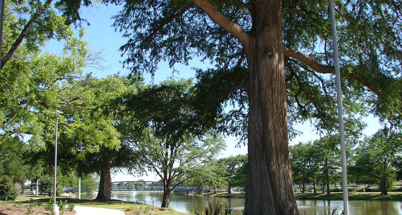
The Apache Creek Greenway is part of the Westside Creeks Trails of HWP Greenway Trail System in San Antonio. It runs approximately four miles along Apache Creek and intersects with several city parks. The Apache Creek Greenway is an important part of San Antonio's Westside community because it ties together neighborhoods that embody the city's rich Mexican-American history and Hispanic culture. The trail extends from General McMullen Drive to I-35 South through dense historic urban neighborhoods.
Location: Apache Creek Greenway is in San Antonio's Westside Neighborhood and runs along Apache Creek from General McMullen Drive to I-35 S.
- States: Texas
- Counties: Bexar
- Cities/Townships: San Antonio
The Howard W. Peak Greenway Trail System (HWP Greenway) is 80 miles of paved hike and bike trails in San Antonio, Texas. The trails run along nine creeks, rivers, and tributaries within the city. There are currently three trails that have been designated as National recreation trails within the HWP Greenway System: the Leon Creek Greenway, Salado Creek Greenway, and Medina River Greenways. The City of San Antonio in coordination with the San Antonio River Authority has invested in growing the trail system to reflect the diversity of the city and is proud to nominate the Apache Creek Greenway for National Recreation Trail status.
The Apache Creek Greenway is part of the Westside Creeks Trails of the HWP Greenway Trail System. It runs approximately four miles along Apache Creek and intersects with several city parks including Elmendorf Lake Park, Cassiano Park, Escobar Park, the (future) Brazos Pocket Park, and Amistad Park. The Westside area of San Antonio was developed in the mid-18th century making it one of the oldest communities in San Antonio. The Apache Creek Greenway is an important part of San Antonio's Westside community because it ties together neighborhoods that embody the city's rich Mexican-American history and Hispanic culture. The trail extends from General McMullen Drive to I-35 South through dense historic urban neighborhoods providing access to several significant destinations including Elmendorf Lake, Our Lady of the Lake University, Boys and Girls Club of San Antonio, public housing communities, Guadalupe Cultural Arts Center, Guadalupe Plaza, the San Antonio Produce Terminal, San Fernando Cemetery No. 1, and downtown.
The Apache Creek Greenway is unique because it serves a community rich in historical and cultural resources that are connected through creeks in an urban environment. These destinations are vital to the community's identity and the trail helps to highlight the connectivity available for bicyclists and pedestrians to access community gems. Our Lady of the Lake University is located one block away from the Apache trail; it was founded in 1895 and is the first San Antonio University to receive regional accreditation. Additionally, the Alazan-Apache Courts were the first public housing communities constructed in San Antonio. The Apache trail is four blocks south of the Guadalupe Cultural Arts Center and Guadalupe Plaza which promote Chicano heritage and culture and host many community events. Guadalupe Plaza has hosted numerous dignitaries and cultural icons including Pope John Paul II. The San Fernando Cemetery No. 1 is also easily accessible from the trail; it is one of the oldest cemeteries in the country and is the resting place for many of the city's key historical individuals. The Apache trail also safely guides users under I-35 South for access to San Antonio's downtown area.
Historically, Apache Creek land was a natural creek way and is part of the Apache watershed that expands 23 square miles across West San Antonio. The creek eventually became channelized as part of the 1954 San Antonio Channel Improvement Project which was implemented as a flood control project. The HWP Greenway Program is funded by a 1/8 cent sales tax, which voters have approved in three subsequent elections. This funding was used to retrofit the drainage channels on Apache Creek to accommodate the trail and to begin the restoration of the creek way. The trails are eight feet wide and paved with concrete, which has proven to be a sustainable material that endures flooding with minimal erosion and minimal maintenance.
The Westside is known for its iconic Public Art, and the Apache Greenway is the future home to two public art projects along the trail. The first project is called "Bloom" by the local artist Leticia Huerta. The art is inspired by native wildflowers and is comprised of metal sculptures created from oversized bicycle parts and is to be located at the future pocket park that will be located at the Brazos Street trail connection. There will be public engagement for a second sculpture on Apache Creek Greenway in 2021.
The Westside of San Antonio is denser than the modern suburbs of San Antonio with narrow roads that are not designed for bicycle safety. Many of the city's bicycle accidents occur on the community's dimly lit roads. The Apache Greenway provides a safe transportation alternative route for bicyclists and pedestrians from neighborhoods to industrial areas and downtown jobs. Furthermore, the Apache Creek Greenway provides historically underserved neighborhoods with walkable access to recreation through the trail system by crossing cultural and socioeconomic boundaries. The trail offers amenities such as exercise stations, wayfinding signage, benches, and public art.
The HWP Greenway Program is managed by the City of San Antonio Parks and Recreation Department. The Department performs all maintenance of the trail and provides trail stewards to assist with trail user needs. The trails are also patrolled regularly by Park Police. Police ensure that trails are being used safely, respond to emergencies that may arise on the trails, and respond to any issues that may need police attention.
The Apache Creek Greenway serves as a vital recreation, transportation, wellness, and cultural resource for the City of San Antonio's Westside community. It connects people from all walks of life to share in the vibrant history of the community bridging its rich culture by enhancing the quality of life through connectivity and recreation.
Accessibility Information
No text provided.
Allowed Uses:
Dogs, on leash Hiking/WalkingOther Activities
- Heritage and history
Public Contact
Daniel LealCity of San Antonio
5800 Enrique M. Barrera
San Antonio, TX 78227
[email protected] • (210) 207-3004
Contact the trail manager for current maps and visiting details.
More Details
- Elevation (low): --
- Elevation (high): --
- Elevation (cumulative): --
- Part of a Trail System? No
- Surface (primary): Paved
- Surfaces (additional): Paved
- Tread Width (average): 96"
- Tread Width (minimum): 96
- Running length (minimum): --
- Tread Grade (average, percent): 2
- Tread Grade (maximum): 7
- Running length (maximum): --
- Cross-slope (average, percent): 2
- Cross-slope (maximum): --
- Running length (maximum): --
- Certified as an NRT
Jun 3, 2021